Software & Platforms
Advanced geospatial software, AI and data platforms built for clarity at scale
Geospatial Intelligence develops and delivers tools that turn complex geospatial data into clear, actionable intelligence. Our platforms support organisations that need fast, reliable insight, from day-to-day operations through to long-term strategic planning.
We combine deep geospatial expertise with modern engineering, machine learning and scalable cloud infrastructure to deliver technology that works where it matters most.

Our platforms
Mission-ready platforms designed for rapid insight
Osprey
AI-powered geospatial processing in your browser
Osprey delivers advanced image processing, AI-driven feature extraction, batch workflows and pay-per-pixel processing, all through a simple web interface.
Built for analysts who need rapid, scalable insight from large imagery collections without specialist hardware.
Mercury
Global AI-driven open-source intelligence (OSINT)
Mercury collects, analyses and georeferences global open-source information including news, social media, reports and public data to provide real-time situational awareness and structured, decision-ready insight.
Custom development & enterprise solutions
Software, applications and AI systems built around your operational needs
Geospatial Software Solutions
Deploy, integrate and optimise the tools that power geospatial intelligence
Our team designs and delivers secure, scalable geospatial solutions across enterprise systems, cloud environments and analytical tools, tailored to real operational needs.
We have delivered workflow improvements within Esri environments for government clients, built custom web interfaces and geospatial databases, and developed continent-scale AI model pipelines for large imagery and data volumes.
Working with Esri, Amazon Web Services and Microsoft, we ensure platforms are modern, resilient and ready for mission use. Ideal for organisations building or expanding geospatial capability.
Application Development
Custom-built geospatial applications designed for real-world operations
Our developers and domain experts build software that brings geospatial data, imagery, analytics and AI together in practical, easy-to-use workflows.
From mobile apps to enterprise platforms, we create solutions that help defence, government and commercial organisations work faster, see more clearly and make better decisions.
We deliver solutions across:
- Web, desktop and mobile environments
- Esri ArcGIS Pro extensions
- QGIS plugins
- Geospatial servers, APIs and cloud-native platforms
Big Data & Artificial Intelligence
AI-powered analysis for faster, more accurate geospatial insight
We apply machine intelligence (including AI, ML and Deep Learning) to identify patterns, detect objects, classify features, monitor change and forecast behaviour across large geospatial datasets.
Our AI capabilities support:
- Object detection and feature extraction
- Segmentation and classification
- Change detection and temporal analysis
- Vessel and aircraft detection
- Predictive modelling
- Multi-sensor data fusion (optical, SAR, AIS, OSINT)
These tools accelerate workflows, improve accuracy and unlock insights that are difficult or impossible to detect manually.
Case Studies

Satellite-Based Oil Spill Monitoring
Synthetic Aperture Radar (SAR) satellite monitoring helped detect oil spills across the Great Barrier Reef, Torres Strait, and North West Shelf, improving response coordination and marine ecosystem protection.Continue reading→
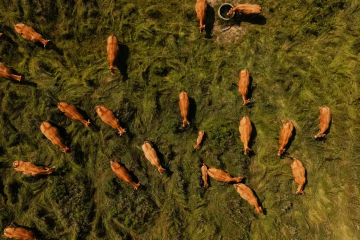
Detecting Biosecurity Gaps in Australia’s Livestock Sector
A geospatial intelligence case study showcasing how OSINT and satellite imagery were used to identify non-compliant livestock sites, improving biosecurity monitoring, traceability, and targeted intervention across Australia’s agricultural sector.Continue reading→
Why work with us
Our technology team brings deep expertise in geospatial systems architecture, backed by full-stack developers with strong experience in Earth observation and remote sensing. We have a proven track record delivering secure, high-performance solutions across defence, government and enterprise environments.
Our AI and software solutions support Australian state governments by enabling the streaming and analysis of large volumes of imagery, helping teams access timely insight when it matters. We have delivered key technology in support of the security of major multinational sporting events, where reliability and speed are critical.
We also develop AI-based feature extraction at scale, including continent-wide forest mapping projects, and support projects for the UK Government across multiple regions worldwide.
By combining robust engineering with AI-driven analytics, we enable faster, more consistent insight. Our platforms integrate imagery, AIS, open-source information and multi-sensor data directly into operational workflows that work in the real world.
Transform your geospatial capability with advanced platforms and analytics
Let’s design, build or enhance the technology that powers your mission