Basemaps, Elevation & Reference Layers
The foundation for accurate mapping, modelling and analysis
Basemaps, elevation models and reference layers provide the essential spatial context needed to understand terrain, visualise information and support geospatial analysis. These foundational datasets underpin planning, operations, simulation, and intelligence workflows across defence, government and commercial sectors.
What these layers provide
Basemaps, elevation data and reference layers enable users to:
-
Consistent Spatial Context
Visualise environments with consistent, high-quality spatial context
-
Terrain Understanding
Understand terrain, slope, visibility and structural relationships
-
Operational Support
Support mapping, planning, modelling and operational assessments
-
Data Integration
Integrate imagery, AIS, OSINT and other geospatial data
-
Mission-Ready Environments
Build reliable environments for dashboards, simulations and mission planning
Basemaps we provide
High-quality, seamless optical basemaps built from extensive satellite imagery archives
-
PlanetScope Constellation
PlanetScope is a global Earth‑observation constellation of 430+ Dove and SuperDove CubeSats that capture daily, multispectral imagery of all landmasses at 3–4‑metre resolution, enabling consistent, high‑frequency monitoring at planetary scale.
-
Sentinel – 1A/1B/1C
Sentinel‑1 is ESA’s all‑weather, day‑and‑night C‑band radar mission delivering frequent, reliable imagery for land, ocean, ice and emergency monitoring through a constellation of identical satellites.
-
Sentinel-2A/2B
Sentinel‑2 is a ESA wide‑swath, high‑resolution multispectral mission using a constellation of identically configured satellites to capture the global landmass with 13‑band imagery at 10–60 m resolution every 5 days, supporting detailed monitoring of land, vegetation, waterways and coastal environments.
-
TerraSAR-X and TanDEM-X (0.25m)
TerraSAR‑X is a German X‑band SAR satellite delivering sub‑metre wide‑area, all‑weather InSAR compatible imagery with outstanding geometric accuracy as part of the Airbus radar constellation.
-
Landsat
Landsat is NASA and the USGS’s long‑running Earth‑observation program, providing the world’s longest continuous land‑imaging record since 1972 to support global environmental monitoring, resource management and long‑term change analysis.
-
Wyvern Dragonette
Wyvern’s Dragonette satellites deliver high‑resolution hyperspectral data with 23+ narrow VNIR bands and 5.3‑metre GSD, enabling detailed chemical and physical surface insights for agriculture, environmental monitoring, and resource management.
-
SPOT 6 and 7
SPOT is Airbus’s broad‑coverage Earth‑observation constellation delivering 1.5‑metre panchromatic and 6‑metre multispectral imagery across 60‑kilometre swaths, enabling fast, reliable country‑scale mapping and monitoring with daily revisit capability.
Terrain & reference data
Essential elevation and spatial layers that provide context for analysis, modelling and decision-making
Elevation Products
Accurate 3D terrain information for modelling, analysis and engineering applications
Available datasets include:
- Digital Elevation Models (DEM)
- Digital Surface Models (DSM)
- Digital Terrain Models (DTM)
- Contours, point clouds and spot heights
Used for:
- Terrain analysis
- Flood modelling
- Line-of-sight and viewshed studies
- Infrastructure assessment
- Environmental and engineering applications
Reference Layers
GIS-ready data layers to support analysis, mapping and operational workflows
Common products include:
- Transport and road networks
- Topographic and relief layers
- Building footprints
- Administrative boundaries
- Thematic and demographic layers
All products are delivered in formats compatible with Esri and other GIS environments.
Case Studies

Geospatial Intelligence Pty Ltd Included in 2018 Australian Military Sales Catalogue
Tuesday 20 March 2018 Today, the Hon Christopher Pyne MP, Minister for Defence Industry, launched the 2018 Australian Military Sales Catalogue at Parliament House. Geospatial...Continue reading→
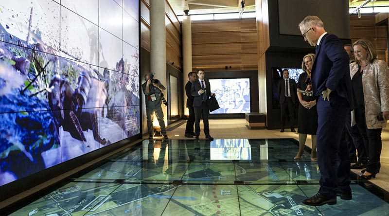
Geospatial Intelligence Proud to Support Sir John Monash Centre
Australian Prime Minister, Hon Malcolm Turnbull, admires the digital displays at the new Sir John Monash Centre in Villers-Bretoneux, including a topographic map of the...Continue reading→

Custom solutions
Our team can develop bespoke basemaps, custom elevation products and specialised reference layers designed for your:
- Operational environment
- Software ecosystem
- Modelling or planning requirements
- Security and hosting needs
We ensure all products integrate seamlessly into your geospatial systems and workflows.
Let us help you select the right foundational datasets for your workflows
Our specialists will guide you to the basemaps, elevation and reference layers that best support your mission