Climate change has become one of the biggest imminent threats to human safety and security in the 21st century. We are required therefore to adapt to these changing conditions, and develop solutions that allow us to manage and quantify the effects of natural disasters faster and much more efficiently. Geospatial Analyst Jeremy Repetto sat down with Geospatial Intelligence’s CEO Rob Coorey to discuss how satellite remote-sensing technologies are vital to this evolution in natural disaster management.
JR: Rob, you’ve been working in emergency response and disaster management even before Geospatial Intelligence was founded 20 years ago – what do you see as the biggest challenges in this uncertain future?
RC: While we can still mitigate some effects of climate change, the latest Intergovernmental Panel on Climate Change (IPCC) report shows that many of its impacts are already being realised. Specifically, changes that the IPCC report refers to includes increases in land and ocean temperatures, as well as more frequent heatwaves, floods, and other extreme weather events. While attempting to mitigate the effects of climate change, we are continuing to respond to these extreme weather events at present.
Natural disasters are not static incidents that only impact their immediate surroundings – impacts are felt regionally, nationally, and even globally. They have the potential to create long-term impacts for all Australians, even after extreme weather events pass. On top of the human impact of natural disasters, uprooting entire communities, the impact to infrastructure, transport routes, supply chains, and the environment can be devastating.
The primary challenge is the mitigation of these effects, which is fundamental to adapting to climate change.
JR: What is required to respond to these kinds of weather events, both now and in the future?
RC: The reality is, with such broad-reaching and long-term impacts, traditional methods of data collection and analysis are too time consuming and limited in scope. Sending out emergency workers to natural disaster zones ultimately raises the risk of harm to those on the ground and their capacity to collect and communicate information concerning extreme weather events.
A change in the way we tackle an increase in these events that climate change is bringing is needed. Australia’s emergency response strategy, in conjunction with state and territory governments, has already begun to revolutionise. Emergency responders have had more engagement and dialogue with local SMEs who are providing innovative solutions to these problems.
For GI, this means being proactive in our response to natural disasters and tackling these issues with a geographic systems approach. GI pre-empt the needs of emergency agencies even prior to request of remote sensing data and analysis from the team. Tasking the collection of satellite data over areas of interest (AOIs) that correspond with predicted extreme weather events ensures capacity to remotely analyse and monitor impacts in near-real time. It also ensures that when emergency agencies make the decision to request GI’s services, we have all of the emergency intelligence needed to monitor the situation closely.
JR: Can you take us through the process that you undertake to respond to natural disasters using a recent situation that you and the GI team responded to?
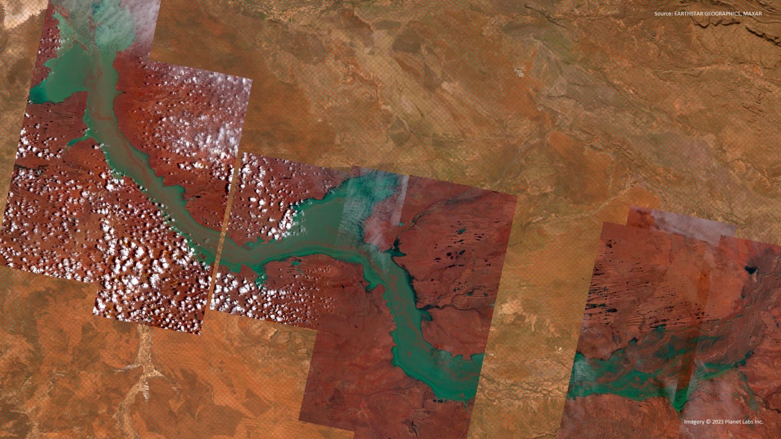
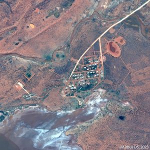
RC: The most recent cyclone Ilsa saw the WA Government approach GI to monitor the impacts of the disaster on several remote indigenous communities located close to the storm’s landfall. Upon receiving the alert that a major weather event was happening in the region, GI had pre-emptively set up captures from a range of satellite sensors over high risk areas. By doing so, we were able to visualise and monitor damage and flooding in near-real time, with a turnaround of just ten hours.
Given the high levels of cloud cover from the cyclone, we used Synthetic Aperture Radar (SAR) satellites during the cyclone event. These satellites leverage radar’s ability to penetrate cloud cover, giving us really clear imagery throughout the storm. Flooded regions really stand out in SAR imagery as well, making SAR a natural choice for tasking during the event.
Following the storm, we captured very high resolution optical imagery of the storm’s effects. Very high resolution optical imagery provides a high level of detail in examining damage to housing and roads, and was used by the WA Government to assess damage and plan safe routes to the remote communities determined to be most in need of assistance.
By using a multi-sensor approach during Cyclone Ilsa and other emergency weather events, GI is able to capture information in far greater detail and faster than is possible with only one imagery source. This continues GI’s long history of working with government during natural disasters and emergency response.
JR: What are your predictions for emergency response and action in Australia over the next year?
RC: The Bureau of meteorology says that there is a fair likelihood of El Nino and dryer conditions beginning again later this year. Many of the extreme weather events we have experienced over the past two years have been linked to too much water, and GI has worked with a range of governments to provide estimates of flood damage and extent in WA and NSW. But it’s important to remember that we’re a country of extremes. While it is imperative that emergency flood response capabilities required in recent years isn’t lost, we need to be prepared to quickly pivot capabilities to a different kind of disaster entirely.
Many Australian SMEs with their intimate knowledge of local environments working in the natural disaster space are uniquely positioned to fulfil this need for manoeuvrability, as their small teams allow for quick decision making and action to occur in times of emergency. GI has been able to do just this in recent years – for instance, GI was able to provide critical intelligence about burn extents across the whole of NSW during the devastating 2020 Black Summer Fires before turning almost immediately to work on the Eastern Australian flood disasters. Weather emergencies will require this capacity to utilise various skillsets in quick succession to appropriately prevent or mitigate the potentially disastrous effects that they may have.
If you want to learn more about how GI supports emergency and natural disaster response here in Australia, please visit our website or email us at info@temp.geoint.global. You can check out the original article on LinkedIn here.